Bruce Trail - Mono Cliffs (Mono Centre)
Meet at the Mono Community Centre parking area, 100m S of Mono Centre. Take Airport Rd 12.7 km north of Hwy 9, then west 6 km on C.R. 8 (Mono Centre Rd) through village of Mono Centre to parking area.
The Town of Mono is situated in south-central Ontario, Canada, at the south-east corner of County of Dufferin, just north of Caledon and northeast of Orangeville. It stretches from Highway 9 along its southern border to Highway 89 along its northern border. Its border to the west is with the Township of Amaranth and in the east it is bordered by the Township of Adjala-Tosorontio. It was previously known as the Township of Mono.
Mono Cliffs Provincial Park lies within the rural town of Mono, in southern-Ontario, Canada, along the Bruce Trail. It is part of the Niagara Escarpment Parks System, and the escarpment Biosphere Reserve.
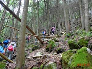
The main entrance to the park is located along the 3rd Line E.H.S. at a pay parking lot with washrooms. The park has seven colour-coded rails for hiking, biking and horseback riding.
- Carriage Trail (red)
- Spillway Trail (blue)
- Cliff Top Trail (green)
- McCarston's Lake (orange)
- South Outlier Trail (yellow)
- Lookout Trail (grey)
- Bruce Trail (dotted)

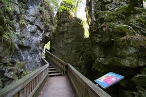
As the name suggests, the park has a number of cliff faces along the Niagara Escarpment itself. Along the Cliff Top Trail is a sturdy set of stairs which descend about 30m down the rock face to a wooden path that runs between the cliff face and a small outlier, providing excellent views of the rock, ferns, and cedars. Caving, rock climbing, bouldering, and scrambling are not permitted anywhere in the park.
754505 County Road 8
Mono, Ontario
Canada